Saturday, May 16, 2015

Big Sur Marathon - Running on the rugged edge of the western world

Its been over couple of weeks since Big Sur Marathon and I still can't stop raving about it. I registered for this marathon last year when I was in the middle of training for NYC marathon. I only started checking the course profile in December and started picking brains of folks who had done this race. One common suggestion from everyone was "Do tons of Hill training". I took that advice pretty seriously and incorporated hilly courses into every long run in addition to standard hill repeats for speed work. Despite all the training I was still nervous and flew to west coast three days prior to the race. After spending a night with family members at San Jose, I drove to Monterey on Friday morning. Picked up my race packet at the expo and spent the next two days getting used to the surroundings. Did my final shake out run with a bunch of runners from Runners world and spent the most of Saturday carb loading and getting my gear ready for the big day.
Big sur Course profile
Alarm went off at 2:45 am and I got ready quickly and was on the shuttle bus to Big Sur by 3:45 am. Met a lot of folks who had done this race few times and it was interesting to hear their interpretation of hills as the bus drove the course in reverse from Carmel to Big Sur. Weather was super comfortable around lower 50s and the race began exactly around 6:45 am and within minutes after the start I found myself cruising comfortably on highway 1. My goal was to run comfortably till half way point and then doing a head-to-toe check to figure out next strategy. First 5 miles of the course is all downhill and I ran without any perceived effort just enjoying the tall redwood trees and the gorgeous surroundings. As predicted, we were running against some serious headwinds. My cap flew few times and I felt my BIB my get torn off at times. Miles 5 to 9 was a slight climb which was clearly an indicator of whats coming next. This is the part of course when you get the glimpse of jaw-dropping pacific coastline on the left and the mountains covered in green moss on the right.


Foggy cloud cover over the mountains made the scene even more spectacular. Mile 9.8 marks the lowest point of the course and also the beginning of the infamous 2 mile climb to the notorious Hurricane Point. The beat of drums got louder at each step and I passed a huge group of Taiko drummers just before this ascent.


I simply trusted my training and took shorter steps and "I can do it" mantra kept running in my head at every turn. To my surprise this two mile climb didn't feel bad at all and even though my pace was slow I was actually passing quite a lot of folks. It was a surreal scene with lots of runners walking and some of them stopping to take pictures of the gorgeous ocean views. It felt absolutely fantastic when I reached the summit of Hurricane point with a ascent of 560 ft in 2 miles. Just after mile 12 I had to remind myself to hold back for one downhill mile as the elevation was dropping by 500 ft.


I made it to half way point in 2:15:32 and after waving at the Piano player Michael Martinez I suddenly felt the urge to pick up my pace.

I was actually feeling comfortable and I passed the 4:30 pacer around mile 15. My goal was to stay ahead of him as much as possible and see if I can catch 4:15 pacer. My legs seemed to be comfortable with hills by then and continued that way till Mile 18 or so. It felt great when I was handed real fruits (orange, banana and water melon) at aid stations. I was getting sick of chewing gels. I passed 20 mile marker in about 3 hour 10 minutes and as expected fatigue started to creep in. I told myself thats normal and continued to push. At mile 23 both my calves started cramping. I had to stop few times to stretch and continue. I probably lost couple of minutes I think. Mile 24 had the best aid station ever as they hand out strawberries dipped in salt. I accepted I have to continue dragging my cramping legs and kept pushing forward. I was bummed I couldn't catch the 4:15 pacer but felt amazing crossing that finish line . My official time was 4:22:13. It was not a PR and about 6 minutes slower than my time at NYC marathon last fall. But I did manage to get a negative split of 9 minutes in the second half. I was pleased with myself to be able to run those hills comfortably. I guess I have to really thank the local hills of Bridgewater and Readington for helping me with hill training during long runs. But one thing I’m not happy about was my pain tolerance level. Moment I started cramping at mile 23 I kind of got into defensive mode. After that it felt difficult to switch to aggressive gear. So I have mixed feelings and I cant help it. Guess that’s some motivation to work harder next time.

Finish Photo Courtesy Big Sur Gallery

Saying this is a gorgeous course is an understatement. It was hard to switch focus between the views and the hills. It truly is a spectacular course and superbly organized race. Here are few pictures I managed while sightseeing around the area.

Foggy evening @ Bixby Bridge
Pacific Grove
Point Lobos State Park
Mcway falls @ Julia Pfeiffer Burns State Park
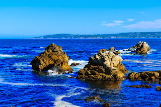
17 Mile Drive

Sunday, April 5, 2015

Sleepy Hollow Half Marathon & Big Sur Training

  
I happened to be in front of computer when they opened registration for Big Sur marathon last year and some how got in within seconds. After NYC marathon in November I did rest my running legs for a while but did some amazing hikes in mighty national parks of Utah (Zion, Bryce & Capitol Reef) in December for couple of weeks. During my time in Utah I also did get few trail runs at various elevations ranging from 5000-9000 ft. It was almost New Year when I returned and my legs felt ready for another marathon training.
Most of my trainings are heavily focused on cross and strength training and running only takes up about 30% of workouts. I did invest a lot of time in January and February building strength & trying to get some leg speed in parallel.  Cold weather and icy conditions kind of forced me to do all speed workouts on the Treadmill. On Tuesdays & Thursdays I spent about 90 minutes to 2 hours beating myself with various strength, core, balancing and plyometric workouts. Then step on the treadmill to do some intervals, hill repeats or tempo runs. Idea was to simulate running on tired legs scenario. For first few weeks they were dreadful and I had hard time keeping 10 min/mile pace on the treadmill. Gradually I embraced the torture and was able to get things going.  I made sure to run long runs on Saturday outdoors (irrespective of the weather) and mapped routes with tons of hills.  All my long runs had about 1000+ ft of ascent and somewhat equal amount of quad busting downhill.
 I invested in lots of cross training like speed intervals on Spinning, Elliptical and stair master machines and a long bike ride the day after long runs.  Swimming and Yoga became great active recovery workouts on Mondays. Weather improved in March and I was able to get few weeks of out door track workout, hill repeats and tempo runs. I was surprised I was able to run about 90 sec-2 min faster than Treadmill and certainly lifted my confidence a little bit.
I felt the need to test myself by running a hilly half marathon and River town runners put up a great race in Sleeping Hollow NY. I ran this race on Mar 21st the day after a big snowstorm. It was cold and windy but roads were quite cleaned up.
I had beaten myself with killer track and tempo workouts and went into the race on tired legs with no expectations. But my goal was to go slightly below my tempo pace for first half and then try to go bit faster. Guns went out and my first mile was flat and my pace was around 7:50 min/mile and I realized if I don’t slow down I’ll regret it.  Next few miles had some ridiculous climbs and my pace naturally fell closer to 9 min/mile. After that I seem to have gotten used to running both uphill & downhill and maintained a steady 8:30-8:45 pace for the rest of the race. I noticed I could never go all out during the whole race due to hilly nature of the course.  Just after mile 13, I wanted to give 100% but that’s where they put a huge climb of over 10% grade. I ran like hell and by the time I was finished I was gasping for air and almost felt like passing out. I looked up my time and it was 1:53:49 seconds and avg pace of 8:37 min/mile.  That was a PR by 70 seconds since my half last year at Adirondack’s half marathon.  For a moment I felt like celebrating, as this was much harder race with 1100+ ft of climb and 1000+ ft. of downhill.
I just wrapped up two more weeks of hard training. Yesterday’s 17-mile long run was mentally and physically hard. I was ridiculously sore and stiff from my track workout on Thursday and throughout the long run it felt like I was running at mile 20 of a marathon. I was glad to be done and I’m very much looking forward to taper for next couple of weeks.  Flying out to San Jose on 23rd and eagerly looking forward to run Big Sur Marathon on the 26th. I’m still nervous about those monster hills & road camber at Big Sur. We’ll see how it goes… Goal is to stay calm and enjoy the race and see what happens.

Saturday, January 10, 2015

Life Elevated Part 4 - Capitol Reef National Park

After three nights at the Center of the universe, I left Escalante and drove east on highway 12 towards Capitol Reef. What an amazing drive. I was stopping at every turn to take pictures. I took pictures of course profile for Escalante Canyon marathon (this starts from Boulder and finishes in Escalante). Thats one of the spectacular marathon courses I've seen. Some of my running friends are going to be hooked at Escalante race after looking at these pictures.


I made a turn into one of the viewpoints about 15 miles away from Capitol reef. This is a point at 9600 ft elevation and you get a spectacular view of the mountains of Capitol reef. Drove on that access road for about 15-20 feet and my car got stuck in a foot of snow. I did everything I could to back off and my 4 x 4 just wouldn't move. Fortunately a couple driving on highway 12 noticed my struggle and came to help. This Gentleman was a local and he got the shovel to clean the snow around and get my car back on the road. I'm really grateful for his kindness. I could have been stuck there for a while. These pictures would explain why I was so excited and didn't pay attention to the snow.


Mind blowing. Never seen anything like this !!


Cloud cleared and finally was able to take this shot.


I finally made it to Capitol reef late noon. Picked up maps from visitor center and did some short hikes at Gooseneck, Panorama and Sunset point. 


Checked into Days Inn, which was probably the only hotel open around here. 

It was sunny 50-degree perfect weather next morning and I had a blast exploring Capitol Reef National park. All those mountains and peaks that appeared tiny from highway 12 were monstrous. I headed to hike Hickman Bridge first thing in the morning. Sunlight was directly on the bridge at around 9 am and lighting was perfect for photography.

Easy hike to get this spectacular natural bridge


Upon descending I drove east on 24 and turned south on Notom Bullfrog road just to enjoy the dramatic scenery and take pictures. Made a U turn after about 10 miles (where unpaved road start). Return trip to the park was equally amazing.


Then drove on Scenic road all the way to Capitol Gorge and did the 1 mile hike. Captured some unbelievable pictures from Pioneer Registry and Tanks.


It was almost 2 pm and after a quick lunch I headed to hike Cassidy Arch. I enjoyed the elevation it provides and the views along the way were spectacular.

But this was one hike that went totally wrong for me. I saw the arch from a distance and a direction indicating it’s about 0.5 miles away. I hiked in that direction for about 20-30 minutes and for the life of me couldn’t figure out where the arch was. Directions to the arch at that point are non-existent. 


I was standing on top of a huge rock and realized I’m lost pretty badly. I moved in all directions for 100-200 feet and couldn’t find any sign of the arch. Frustrated returned back to the trail and I had a struggle finding it too. Anyway I barely made it to the car by sunset and drove back to the hotel.
I checked at the visitor center at Capitol Reef and ranger told me for Cassidy Arch you end up on top of the arch.Thats exactly where I was and I'm relieved I wasn't lost.. :) .
I went back to the park next morning for a run and saw sun, rain and snow all within 1 hour of my run. It was quite dramatic.

Saw this beauty during the run on Scenic drive.
Decided Capitol Reef would be my last destination in this trip.There is no point pushing to reach Moab/Canyon-lands/Arches when I cant do justice to those parks. I'll probably do those parks another time. I had two more days to get back to Vegas and I decided I'll drive back west and take my time to transition my legs from hiking to running mode. I stopped at Bryce canyon for a night and was able to run at 9000 ft elevation for an hour and felt quite comfortable doing it. Next day I headed to Zion to spend a night and ran Angel's landing hike to Scout's lookout which was equally comfortable. I felt acclimatized to higher elevation.. Too bad I couldn't stay here and train for my upcoming marathon at Big Sur. Made it safely back to Vegas and then flew back home to NYC without any issues. I'm incredibly thankful to my friend / colleague for suggesting this trip and for all the inputs and guidance he poured on. And also huge thanks to destination experts at Trip advisor for their tips in making this a successful & safe trip. Even after two weeks I feel like I haven't seen anything and cannot wait to go back to explore the elevated grandeur of these national treasures.


Life Elevated Part 3 - Center of the Universe

After a fabulous day at Kodachrome State park & Bryce Canyon, I headed back to Escalante a.k.a "Center of the Universe". I still didn't get a chance to do the hikes I wanted at Bryce. Guess I will have to make another trip during warmer weather to explore Bryce. I had booked two more nights at Circle-D Motel. But I was clueless as to what to do next two days. Firstly it's all backcountry trails with muddy unpaved access roads. Secondly I'm beyond pathetic in route finding & navigation in backcountry.  I found a brochure for "Escape Goat Day Tours" that had guided hiking services to slot canyons  near Dry fork . The owner Shawn was gracious enough to take my call late in the night & agreed to take me on a hike to Dry fork, Peekaboo & Spooky gulch canyons next morning.  He promptly came over next morning at 8:45 am & we were off driving on Hole-in-the-rock road.  We quickly developed a good rapport & were exchanging backpacking ideas around Escalante. We stopped on Hole-in-the-rock rd to take a shot of this cloud formation.

View from Hole-In-The-Rock road
Road conditions got pretty bad after 15 miles on Hole in the rock & I was relieved that Shawn was behind the wheel. It was exceptionally great day weather wise for hiking. It was sunny and mid-morning temps were in the perfect upper 40s. We finally made it to Dry fork parking lot by 11 am which was deserted and  we were the only ones there. We climbed down the rocks from parking lot and as we were heading towards the Dry fork slot canyon spotted a a lone Coyote which sensed our presence and disappeared in seconds. We hiked Dry fork gulch canyon first and Shawn told me to enjoy somewhat wider canyon as it was only going to get claustrophobic.


Couldn't have done this at Spooky or Peek-a-boo
After reaching the top of Dry fork slot canyon we hiked out of the canyon and walked on the access road to get back to  on the Dry fork gulch. We saw couple of guys entering Peek-a-boo Canyon but we walked further to hike Spooky first. Spooky slot canyon was ridiculously claustrophobic and I was pleased that I wasn't doing it alone.


Climbing out of Spooky gulch was quite challenging for me as I'm not used to rock climbing or even scrambling of any kind. For a moment I felt my waist was stuck between two rocks  and I was glad Shawn was there to help me climb those narrow rocks.  I usually panic and make such a hike more complicated than it usually is.. The two tourists who we saw at entrance of Peek-a-boo were already there patiently waiting for this amateur to climb out of Spooky.


It surely wasn't as easy as it looks here.
Entered Peek-a-boo and it felt lot easier than negotiating the climbs at Spooky.  It was really short hike and I was sad it was over even after all those nightmares hiking out of Spooky.


Part of the hike where I felt like a kid
We saw about 8-10 more tourists as we were heading back to the parking lot.  Once we got back to the parking lot we saw a note from park rangers that a cow had died few days ago inside the slot canyon and they were unable to remove all dead parts completely. I didn't remember smelling anything funny in any of the canyons. Probably it explains why the Coyote was wandering around the canyon entrance. Drive back to Escalante was smooth. We stopped at Devil's Garden for few minutes but I ran out of battery in my camera for pictures.  Guide Shaun was awesome. I'm so glad I chose to hire a guide. If I had ventured on my own I would have turned back half way on the Hole in the rock road. He suggested I plan to hike Zebra / Egypt 3 canyons during my next trip. I laughed in my head about my survival just visualizing myself in those canyons.  I was pretty exhausted by day's affairs but did manage to do a quick run at Escalante Petrified Forest trail before crashing & burning for the night.

I was simply blown away by the endless hiking options around Escalante.  It surely would take few more trips to even make a dent on the Grand Staircase Escalante National Monument.


Life Elevated Part 4 - Capitol Reef National Park